On the go in the southern French Alps, following the Durance river
30 September, 2021
The Durance rises in the mountains near Briançon. We follow the river downstream and show you the highlights of the southern French Alps.
300 days of sunshine per year
The Southern Alps (Alpes du Sud) are located in the southeast of France, stretching over the provinces of the Rhône-Alpes and Provence-Alpes-Côte d’Azur. The Durance rises in the north of the region. Via the city Briançon and Lake Serre-Ponçon, the river travels towards the Provence in the south, only two hours from the Mediterranean Sea. The sunny mountains – the sun shines an average of 300 days per year – abounding with typical old villages, national parks, nature reserves and countless opportunities for hiking, cycling, water sports and camping, simply clamour to be discovered.
Glaciers and lavender
A rich pallet of picturesque landscapes unfolds between the Écrins and the Mediterranean Sea, from the high peaks to the Mediterranean coasts. The light blue of the glaciers is never far away from the purple blue of the lavender. The countryside is impressive and rich and can be enjoyed the entire year round. Life is clean and pure here. And this most certainly applies to the local cuisine as well.
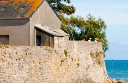
Briançon und Mont-Dauphin

Briançon and the fortified town Mont-Dauphin are on Unesco’s World Heritage List because of the famous French fortress builder Vauban. Photo: C. Marchand.
Briançon is the third highest city in Europe and the highest city in France. In the 18th century, the famous French fortress builder Vauban built many defence works around the city to safeguard the access road to Italy. The combination of impressive fortresses, old buildings and streets make Briançon a place that is more than worth the trouble to visit.
It is also an ideal operational base for high-altitude sporty trips. Excellent opportunities for winter sports are offered in the nearby areas of Serre Chevalier and Montgenèvre. Italy is only a stone’s throw away. Like the defence works of Briançon, Mont-Dauphin is also on Unesco’s World Heritage List. The town is located high on a rocky plateau above the confluence of the Guil and Durance rivers.
Écrins National Park
If you follow the Durance, you will end up in the Vallouise valley, which is part of the Écrins National Park. The park is famous for its glaciers, and there are dozens of mountain peaks that rise above three thousand metres. The Barre des Écrins has a peak elevation of 4,102 metres, making it the most southern mountain of more than 4,000 metres in the French Alps and also the name giver to the park. Up until 1860, this was the tallest mountain in France.

More than 600 ibexes (mountain goats) and 15,000 chamois (goat-like antelopes) live in Écrins National Park. Photo: alpesphotographies.co
In 1973, the Massif des Écrins became a national park – the largest in France. It is an ideal area for hiking, mountain biking, mountain climbing and rafting and, of course, for ski trips in the winter.
Campsites in the Écrins
Queyras Regional Nature Park
At the same altitude but then on the east side of the Durance and close to the border of Italy lies Queyras Regional Nature Park. It has not yet been discovered by mass tourism and beautiful authentic villages can still be found there. The Queyras offer numerous opportunities to enjoy being active. Hikers in particular can indulge themselves in these mountains. The park has plenty of well-marked paths. But there are also many opportunities for cyclists, mountain bikers, climbers and winter sports enthusiasts.
Campsites close to the Queyras
Lake Serre-Ponçon

Lake Serre-Ponçon is an ideal location for all kinds of water sports. Or simply go for a refreshing dip. Photo: Le naturographe Hautes-Alpes.
More to the south, the Durance widens out in Lake Serre-Ponçon. This reservoir was built halfway through the twentieth century to regulate the Durance and is famous for its turquoise-coloured water and rugged bays. The impressive dam of Serre-Ponçon is one of the largest earth dams in Europe, being 123 metres high and 650 metres long. There are plenty of activities to be done both on and around the lake.
At the same time, there is a rich variety of cultural heritage, such as the Embrun Cathedral, the abbey of Boscodon, a masterpiece of Roman art, and the church of Savines-le-Lac. At the mouth of Lake Serre-Ponçon lies Embrun, nicknamed ‘Nice of the Alps’ due to its mild climate.
Campsites at Lake Serre-Ponçon
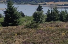
Seven nature parks

The southern French Alps have an unusual geological history. You can travel back in time in the Unesco Haute-Provence Geopark and the Cottian Alps Geopark. Photo: Epix
The Durance forks just past Lake Serre-Ponçon. The Ubaye is a tributary of the Durance and flows through the Ubaye Valley. This valley contains rough mountain streams, tranquil mountain lakes, rocks and peaks of more than three thousand metres. This is a beautiful area to actively explore. In the summer, when the river is engorged with meltwater, it is a much-loved area for rafting, wild water canoeing and other water sports.
A short distance upstream, past the Maddalena Pass and the Col de la Bonette, lies the Mercantour National Park, a true paradise for hikers. The southern Alps contain a total of seven nature parks, the newest of which is the Baronnies Provençales Regional Nature Park. It is located on the border on the Rhône-Alpes and the Provence-Alps-French Riviera, in the amazing Buëch country. Le Luberon Nature Park lies on the southwestern border of the southern French Alps. This is where our trip downstream ends. Not much further on, by Avignon, the Durance flows into the Rhône.
Route des Grandes Alpes
To cross through the southern French Alps, you can follow the Durance as described above or take the Route des Grandes Alpes. The 720-kilometre-long route goes from Thonon-les-Bains by Lake Geneva to Nice on the Mediterranean Sea. The Route des Grandes Alpes is a popular route for cars and motorcycles, but some cyclists dare to take on this challenge as well.

The southern French Alps are a fantastic destination for sporty and active holiday vacationers. Photo: Armand Alps Epix
Along the way, you drive though breathtakingly beautiful countryside, and you go through sixteen Alpine passes. These include the Galibier and the Izoard, mythic cols of the Tour de France. Road construction through the French Alps began in the 18th century. The first buses drove over (a part of) the Route des Grandes Alpes 110 years ago. It became possible to follow the entire route through the French Alps when the Col de l’Iseran was opened in 1937.
Main photo (at the top of this blog): Bertrand Bodin
This blog appeared earlier on ACSI FreeLife.nl (Dutch website)

Latest comments